


Perhaps you’re considering building a log home in or near the Smokies and want to know more about the area. Or, maybe you’ve just moved here and you’re ready to embark on your first hike. Whatever your reason, it’s always a great time to get out and explore some of the hiking trails in the Smokies.
With so many trails to choose from, sometimes the toughest part is deciding which one to hike. How do you choose? Do you decide by the area the trail is located in the Smokies, its length, its difficulty, what you’ll see along the way? There is no wrong way to decide which trail to hike, just as long as you’re out there!
Here are 7 of our favorite trails to get you started:
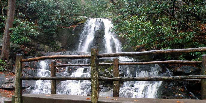
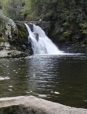
1. Laurel Falls
Length: 2.6 miles roundtrip
Difficulty: Easy
The trailhead is located on Little River Road, between Sugarlands and Townsend. There is plenty of parking for this popular trail.
Young children could easily walk to Laurel Falls. It follows a paved trail, so it is even accessible to strollers. Mountain laurel blooms in abundance on this trail, making for some beautiful late spring/early summer scenery. The trail passes through outcroppings of sandstone over which Laurel Branch falls. This is quite beautiful and can be crowded. The 80-foot waterfall is one of the most photographed spots in the Smokies. Go check it out!
2. Porters Creek
Length: 2 miles or 3.6 miles roundtrip, depending on where you turn around
Difficulty: Easy
The trailhead is in the Greenbrier section of the park, on highway 321. Parking is available.
The first section of the trail is a very easy walk, suitable for all ages, with an abundance of springtime wildflowers. The trail follows Porters Creek, an area rich in history. Throughout the hike, you will see old home sites and fences. About 0.7 miles into the hike, just past a bridge, you will come to an old cemetery you may wish to explore. The trail continues to follow Porters Creek until it crosses a small stream. On the other side of the stream, you’ll find a gravel loop. The Smoky Mountain Hiking Club cabin is to the right. This is one mile from the trailhead and is a good place to turn around if you have children.
If you wish to keep following Porters Creek Trail, you will continue past the loop. This easy hike passes above Porters Creek and through an eastern hemlock forest. At the 1.5 mile mark, you will cross Porters Creek on a foot log. Use caution here, as the creek can be quite deep. You will hike another 0.3 miles to Fern Branch Falls, a beautiful, 45-foot waterfall to the left of the trail. We recommend stopping for some R&R before turning around and heading for home.
3. Little Greenbrier
Length: 1.4 miles roundtrip
Difficulty: Easy
The trailhead is at the Metcalf Bottoms picnic area, about 10 miles from the Sugarlands Visitor Center. There is plenty of parking at Metcalf Bottoms.
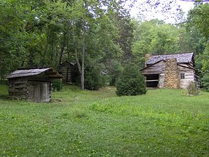
To begin your hike, cross the bridge to the other side of the Little River. You will have to go around a gate that blocks off a gravel lane. You will follow the gravel lane up and to the left, past a water tower. The scenery is beautiful through this area, with mountain laurel and rhododendron in full bloom. You will walk down to a flat area that was once farmland. A nice creek runs through here, and children enjoy splashing in the cold mountain water. Continuing on the trail, you will come across two-foot logs located fairly close to one another. From the second foot log, you should be able to see the Little Greenbrier Schoolhouse.
Little Greenbrier is the former homestead of the Walker sisters, five spinsters who received the land from their father and refused to sell their 123-acre farm to the national park. You will be able to tour the inside the Little Greenbrier Schoolhouse and look through the cemetery. If you continue just a little further up the trail that leads off to the side, you will come upon the Walker Sisters’ home. This is a nice, easy, educational hike for everyone.
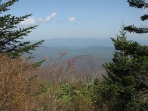
4. Andrews Bald
Length: 4.2 miles roundtrip
Difficulty: Moderate
The hike begins at the Forney Ridge parking area at the end of Clingmans Dome Road. Keep in mind the trailhead is often not accessible by car during the winter and early spring.
You will start your hike on the Forney Ridge Trail, which is quite rocky and may be difficult for younger hikers. At the 0.1 mile mark, take the left turn; otherwise, you will go to the Appalachian Trail. The trail will become easier to navigate after the first mile. As you continue on the trail, you will notice the spruce forest becoming denser and ferns growing more abundantly. The trail opens onto a grassy bald, which offers spectacular, panoramic views of the Great Smoky Mountain highlands and Fontana Lake. Flame azalea and rhododendron are extraordinary in June. You and your family will not be disappointed in this hike.
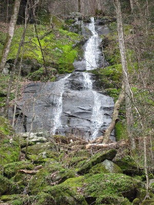
5. Abrams Falls
Length: 5 miles roundtrip
Difficulty: Moderate
To begin this popular hike, travel the Cades Cove Loop Road for about 5 miles until you cross Abrams Creek. Take the right turn after the creek, and you will find a parking area about 0.5 miles down the gravel road.
Take the footbridge and follow the path along Abrams Creek. This peaceful hike will take you through forests of pine, oak, and hemlock, as well as rhododendron, mountain laurel, and spring wildflowers.
Along the trail, you climb three different ridges. You will be able to hear Abrams Falls well before you see it. When you arrive at the falls, you may be surprised that a waterfall only 20 feet high can produce such a roar. With 18 creeks flowing in to create Abrams Creek, it’s no wonder the amount of water rushing over the falls is so staggering! Abrams Falls not only boasts the largest volume of water, but it also prides itself on having the deepest pool in the Smokies. It is quite a pretty and popular location. Be sure to use caution around the falls: look but don’t swim!
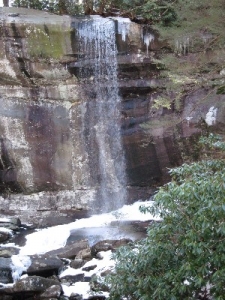
6. Rainbow Falls
Length: 5.5 miles roundtrip
Difficulty: Moderate to Difficult
To get to the trailhead, take traffic light #8 in Gatlinburg and go 3.4 miles to the Rainbow Falls/Bullhead parking area.
On this hike, you will use the same trail as hikers traveling to Mt. LeConte; you just won’t hike as far. The trail follows LeConte Creek up to the falls. At the first mile marker, you will be able to get a nice look out over Sevier County. You will pass under large hemlocks and abundant rhododendron, and over two footbridges, on your way to the falls.
At 80 feet, Rainbow Falls is impressive; it is the highest single plunge water takes in the Smokies. Often, the afternoon sun will shine on the falls producing a rainbow effect, from which Rainbow Falls gets its name.
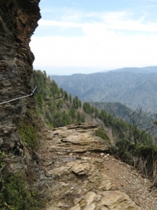
7. Mount LeConte
Length: 11 miles roundtrip
Difficulty: Difficult
The trailhead is located on Newfound Gap Road, 8.7 miles south of the Sugarlands Visitor Center. You will be using the Alum Cave trailhead.
The summit of Mount LeConte is just under 6600 feet up, offering outstanding views and spectacular sunrises and sunsets. But, before you get to the top of Mt. LeConte, you will first follow the Alum Cave Trail. At the 1.3 mile mark, after traveling under bountiful rhododendron, you will reach Arch Rock. You will walk up several stone steps before exiting the top and heading onto Inspiration Point, 2 miles into the hike. Take a moment here to enjoy the beautiful scenery.
Continuing up the trail, you will reach Gracie’s Pulpit at the 2.6-mile mark. This landmark, named after Gracie McNichol, who hiked to Mt. LeConte on her 92nd birthday, is the halfway point on your hike. From here, you will hike another 2.5 miles to the junction of the Alum Cave Trail and the Rainbow Falls Trail. Turn right here.
Next, you will come to Mt. LeConte Lodge. (If you wish to stay in the lodge, you will need to make reservations well in advance.) Many people stop their hike at the lodge; however, to reach the summit of Mt. LeConte, you must continue on another half-mile. You will know when you have reached the highest point, known as High Top, when you see a cairn, or pile of rocks, just off the main trail on the right.
This is a challenging hike with plenty of rewards along the way. It’s a must-hike for anyone ready for an adventure.
There are over 800 miles of hiking trails in Gatlinburg and the surrounding areas, so this post just scrapes the surface of all the Smokies have to offer.
Always remember the hiking basics: Never hike alone; always carry water, a flashlight, and a first-aid kit; and, wear appropriate shoes. The mountains are fun, free, and right in our back yard. Take advantage of them today!